‘Terra Nullis’ revisited
 In 1994, I was Guest Lecturer and Artist-In-Residence at Claremont School of Art, in Perth, Western Australia. I researched and created a new body of work for an exhibition there which focussed on the voyages which brought the first Europeans, by default, to Western Australia, where they declared the land to be ‘Terra Nullis’, empty land/ nothing there. Of course, there had been Aboriginal peoples living there for upwards of 50,000 years, but because they do not build buildings and settlements recognisable to European eyes, it was considered unoccupied, and thus began European occupation and dispossession of its indigenous inhabitants.
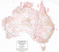
I was thus really interested to see the Norman Tindale map in the South Australia Museum in Adelaide.This Museum has the largest collection of Aboriginal artefacts in the world, and some truly exquisite objects and many bark paintings. The Tindale map was an act of quiet controversy when it was published, as it was the first to attempt show how all Australia is divided into multiple Aboriginal tribal territories, declaring rights of ownership over every bit of Australian territory, and was thus an important political statement. The map took over 50 years to collate.
